By Zac Robinson
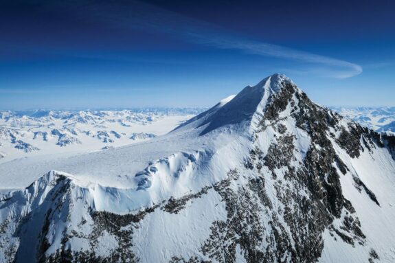
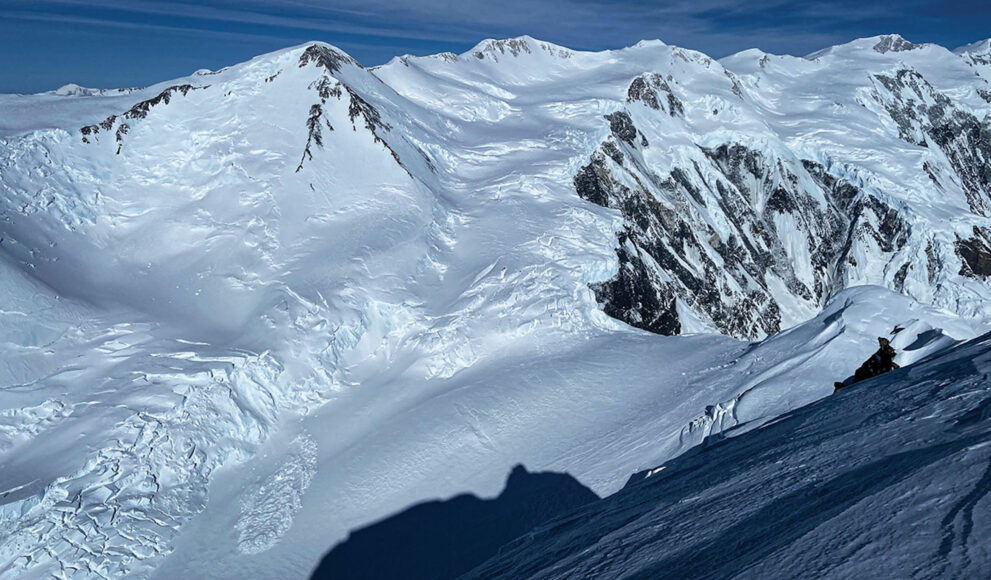
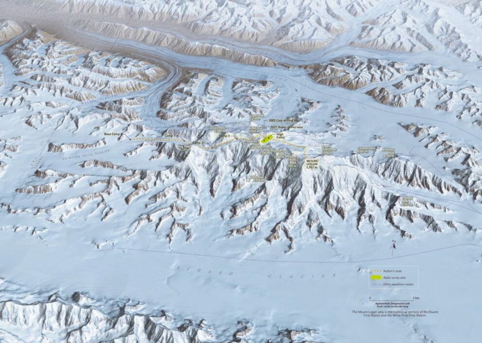
On May 15, 2021, under a clear and windless sky, Alison Criscitiello and I skied out onto Mount Logan’s glaciated summit plateau. From the Yukon mountain’s base, it had taken us and two friends — Rebecca Haspel, a geologist from Calgary with a serious talent for self-propelled adventure, and Toby Harper-Merrett, a Montreal-based climber and vice-president of the Alpine Club of Canada — nine days to reach this 20-kilometre-long expanse of snow and ice. At 5,000 metres, we were finally on the so-called “Roof of Canada.” From the edge of the massif’s high tabletop, Mount Logan’s various subpeaks rose before us, adding depth and shadow to the dazzling white-and-blue expanse. To the north, a sea of mountains and ice stretched out before us as far as the eye could see. The view was as breathtaking as the rarefied air.
But we hadn’t the luxury to appreciate the scene. For we had just learned, via satellite communication, that the stable, high-pressure weather window we had enjoyed for much of our ascent was closing. At best, a couple of days remained — enough, perhaps, had our goal been to quickly tag the top, wave a flag and descend. But that wasn’t the objective. We had come in service of science, to investigate climate and change at Canada’s highest elevations and to lay the necessary groundwork for a future visit to drill for, and collect, ice samples from the mountain’s summit plateau. After two years of planning, six months of training and 14 days of pandemic quarantine in Whitehorse, we were now, finally, exactly where we needed to be. And time was suddenly against us.
As if climbing Mount Logan wasn’t hard enough.
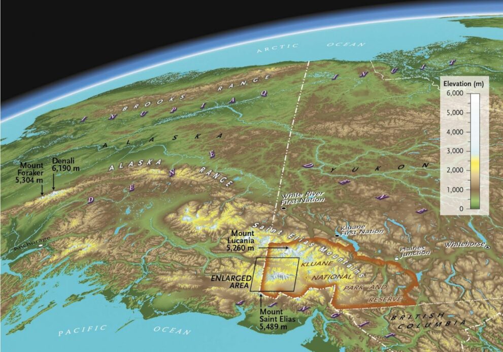
Located deep within Kluane National Park and Reserve in the southwestern corner of the Yukon, and within the traditional territories of the Kluane and White River first nations, Mount Logan stands unrivalled in physical mass, and perhaps in mountain grandeur. The massif boasts the largest base circumference of any non-volcanic mountain on Earth. Twelve distinct peaks rise from its summit plateau. Its many sawtooth ridges rake moisture — like “a cosmic comb,” one writer described it — from the almost countless, year-round storms produced over the Pacific Ocean (as the warm, wet air is deflected up the windward side of the wall of mountains, it condenses into storm clouds that drop their moisture before cresting the summits). Average summer temperatures on the summit plateau are sub-zero, and tremendous snowfall in the region produces an area of glaciation smaller only in size to those found in the polar regions of Antarctica and Greenland. Few places on Earth are as high, cold and remote as Mount Logan. All told, it’s a coveted prize for climbers around the world — and a unique site for studying climate change.
The genesis of our initiative was decidedly less elevated.
Our story begins far from Mount Logan in the flat parkland expanse of central Alberta, on the floor of a university laboratory, in a warm puddle of ancient water. The New York Times called it “An Ice Scientist’s Worst Nightmare.”
Ice cores hold climate secrets of long ago. The long, cylindrical cores drilled from glaciers in high mountain and polar regions preserve information — gas bubbles, pollen, dust particles, trace elements and isotopes — that scientists can use to reconstruct the Earth’s past climate and air composition. The techniques to analyze ice cores, and the range of information that can be extracted from them, are always advancing, so the collecting and archiving of these ice cores is vitally important.
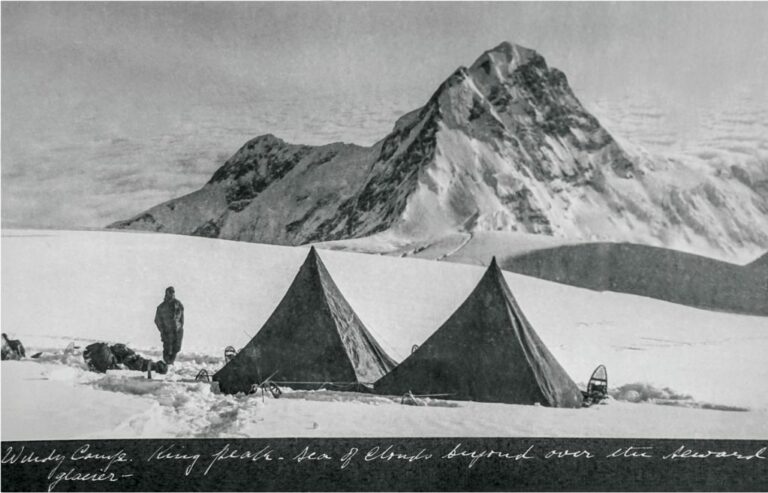
A catastrophic freezer malfunction in 2017 at the brand-new ice-core lab at Edmonton’s University of Alberta damaged or lost roughly 10 per cent of its samples. The facility had been custom-built to house the world’s largest collection of ice cores from the Canadian Arctic, and the meltdown was heart-wrenching for the institution, its researchers and the wider scientific community. Among the damaged samples was the oldest ice-core record ever collected from the north Pacific region, drilled in 2001 and 2002 by a team of federal government scientists on Mount Logan’s plateau, on a wide glaciated saddle between Prospector’s and Russell peaks. The sample, retrieved from drilling 180 metres deep, to bedrock, had provided scientists with a window into 16,000 years of climate history, making it one of the most valuable non-polar, high-resolution records of atmospheric climate change for the region.
In the incident’s immediate aftermath, unrelatedly, the university hired Alison Criscitiello to manage the new ice-core facility. The Boston-born, MIT-trained chemist knew what it took to collect cores in extreme, hard-to-get-to places. She had drilled across the Canadian Arctic, in Greenland and in the Antarctic. As a climber, she would also soon come to know Mount Logan, successfully ascending the peak herself in spring 2018. Could anyone who knows Criscitiello — cool, resourceful, energetic-to-the-max (the type of person who happily runs marathons, daily) — believe for a minute that plans for an ice-core rescue mission weren’t soon to follow?
I first met Alison Criscitiello at a coffee shop near the university’s campus early in 2019. We yakked about parenting, mutual climbing friends and our own research projects. All grin with tight curls suspended just below her distinguishing beanie toque, she explained how advances in modern-day, ground-penetrating radar could help her and her team locate an even better drilling site on Logan’s plateau and thus yield a superior ice core.
But that important radar work would require an initial expedition to the mountain. For my part, as a historian, I also hoped to return to Mount Logan to try to repeat a series of photographs taken up high during various mountaineering ascents over the past century. The comparison of images, old beside new, might reveal something, I figured, about climatic warming at high elevations. My objective took a historical view; Criscitiello’s was all forward-looking — but both projects revolved thematically around change on Canada’s highest peak. We cheerily resolved to team up.
But, within eight months, as the first wave of the global COVID-19 pandemic swept the country, all designs for a 2020 expedition — like pretty much everything else — ground suddenly and stunningly to a halt.
That rapid change is occurring today across the Yukon’s glaciated landscape is hardly a surprise. It’s well known that the rate of temperature change — caused by increasing levels of greenhouse gases in the atmosphere — is amplified at high latitudes. This was driven home in 2010 when researchers first compared aerial photographs from the Canadian Land Survey in the 1950s with modern-day satellite images and found that of the 1,400 glaciers surveyed a half-century ago, 300 had disappeared. And nearly all others had shrunk. “It’s a regional thinning rate that is greater than almost all other glacier and ice-cap regions,” said geophysicist Nick Barrand, who was one of the study’s lead authors.
There is growing evidence those rates of warming are also further amplified at elevation, meaning that the world’s highest mountain ranges are warming more rapidly than their surrounding lowlands. That’s a double whammy for Canada’s high northern mountains. And this appears to be the case for Mount Logan, at least according to a 2020 study that used an array of meteorological data to show that the air near the mountain’s top was warming more rapidly than at its lower slopes.
Could we see this change on the mountain’s upper slopes? On its snow-and-ice-encrusted summit? Repeat photography would get us part of the way, but it wasn’t until 2020 — remembered as our sedentary year of unhappy low-lying postponement — that another line of investigation rose up before us. And this one, too, had a history.
In March 1975, Gerald Holdsworth, an eminent ice-core scientist who had long worked in the Canadian Arctic, penned an article for the Canadian Geographical Journal titled “Taking the measure of Mount Logan.” It neatly laid out a near century-long preoccupation among surveyors and climbers to determine the exact height of the Yukon’s Saint Elias Mountains. “An element of mystery often surrounds regions of very high altitude,” wrote Holdsworth. “Mount Logan, the highest point in Canada, is no exception.”
That mystery was finally laid to rest in 1992, when an expedition sponsored by the Royal Canadian Geographical Society established Mount Logan’s official height, with the use of GPS technology, at 5,959 (+/-3) metres above sea level. In that year, the GPS — or global positioning system, a project that had been initiated in 1973 by the U.S. Department of Defense — was still three years away from being fully operational. This meant that the 1992 team, equipped with early-generation GPS receivers, had to carefully time their summit bid to coincide with the position of satellites orbiting far overhead. It was a remarkable feat. The expedition was a signature commemorative event for the 150th anniversary of the Geological Survey of Canada, as well as Canada’s 125th birthday.
Since then, GPS technology has advanced significantly, especially in terms of its ease of use, reliability, accuracy and ability to process data. Today, high-quality receivers pick up all non-military signals from the much larger global navigation satellite system. That system encompasses the U.S. GPS, Russia’s GLONASS, the European Union’s Galileo and others. Combined with advances in data processing and analysis techniques, today’s receivers provide incredible all-weather positions, including measuring the height of mountains within several centimetres. Modern instruments can also record data 24 hours a day. And with significant improvements in the modelling of sea level under mountains — the theoretical surface known as the geoid — elevation measurements are even more accurate.
For all of these reasons, Michael Schmidt, a longtime geophysicist with the Geological Survey of Canada and the indomitable team leader of the ’92 expedition, asked us if we’d be willing to remeasure the height of Mount Logan’s main summit using modern global navigation satellite system receivers. And “it would not be surprising,” Schmidt added, “to see a difference from 1992 as a result of the variability in summit snow and ice over time.”
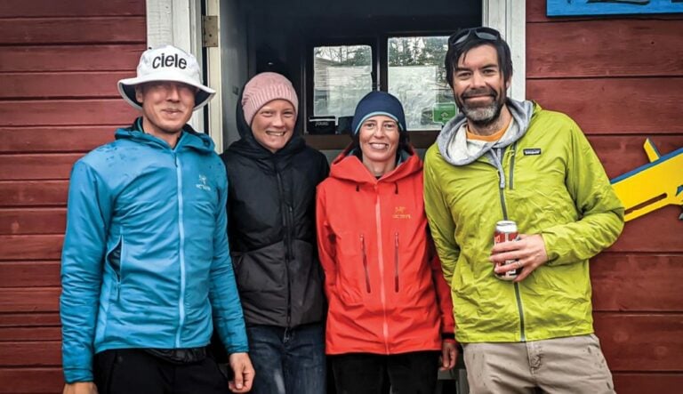
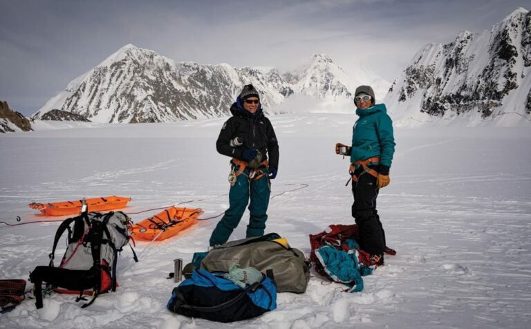
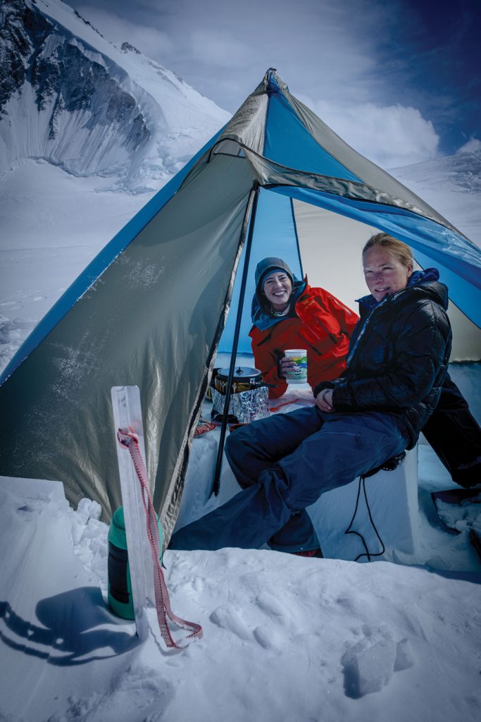
As the spring of 2021 drew near, and despite continued waves of pandemic concern, the possibility of an expedition to Kluane National Park and Reserve improved. International travel restrictions, however, necessitated adjustments to our group’s composition and size. The four American ice-core scientists on Criscitiello’s team had to withdraw because of the border closure. We quickly looked closer to home for assistance, and enlisted our friends Rebecca Haspel and Toby Harper-Merrett. By mid-April our team of four was happily holed up in a Whitehorse rental unit to fulfil a two-week quarantine period, which we spent organizing and repacking gear, familiarizing ourselves with various scientific gadgets and keeping active as best we could.
The topic of change was central to much of our quarantine conversation. In particular, a contemporary aerial photograph enflamed our imaginations — and our concern. A day after arriving in still-snowy Whitehorse, Conrad Janzen — a Parks Canada visitor safety specialist from Banff who was participating in helicopter-rescue training with Kluane Park staff — shared with us a rare bird’s-eye view of the upper portion of Mount Logan’s King Trench Route. It was the route we were planning to ascend to access the mountain’s upper plateau. The image came with a message: “things are changing.” What used to be one or two potentially show-stopping crevasse systems (deep, open cracks) across this portion of the glaciated route now looked like four or five. And the snow cover was remarkably thin. We shared the image with Schmidt, who now lives in Kluane’s gateway village of Haines Junction, not far from our staging area on the shores of Łù’àn Män (Kluane Lake). “I am totally amazed by the changes from 1992,” Schmidt said in an email. “If you can believe it, we simply slogged up through the snow, wound our way around very few crevasses, with the return ski down cranking turns the whole way with no concerns at all!”
Schmidt’s snowpack observations were echoed soon afterward by Sian Williams, the seasoned, second-generation outfitter at Icefield Discovery, a full-service air-charter company that has been transporting climbers to the base of Logan for decades. “Twenty years ago, we’d often have to dig out our five-metre-high cache marker out on the divide,” noted Williams of the central accumulation zone that feeds a whole hub of glaciers in the region. “Now, we rarely get over two metres [of snow].”
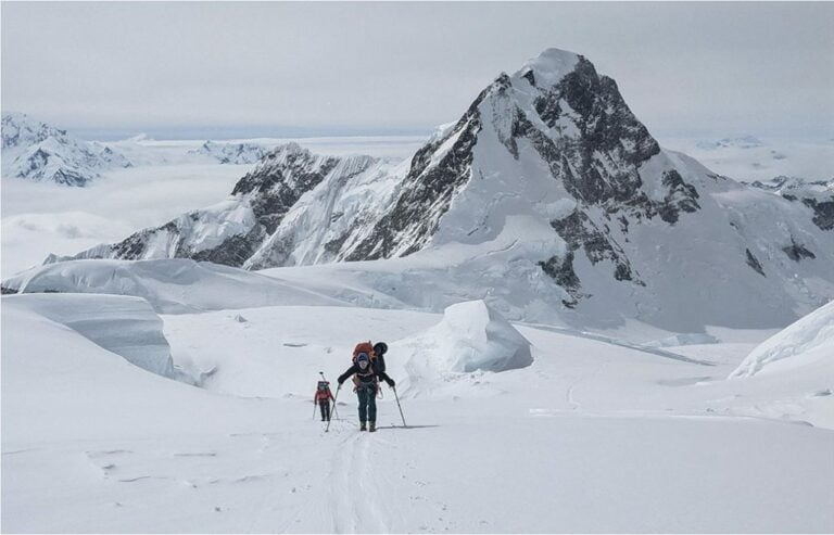
While the image instilled a healthy dose of trepidation, it also gave us an upper hand, at least as far as navigation went. Once on the mountain, we often referred to the photograph, and with it, our journey thus proceeded happily, the first day morphing into the next, as we pushed upward on skis, roped together, laden with heavy packs and sleds. We relished the physicality of it all, of finally being able to move after our prolonged delay. Eight days and three camps later, we were dug in comfortably just below Prospector’s Col, a small granite gap on the upper route and the entryway to the plateau.
It was here that we received the news that the weather was changing for the worse. Haste was now required, or we risked getting stuck high on the mountain, exposed with little protection for an indeterminate period of time. There’s nothing quite like necessity to bring about efficiency. Strong, capable and supportive climbing partners help, too.
Most people take a rest day before a summit attempt. We played high-altitude tire-pull. All in the name of science.
What ensued was a three-day barrage of methodical precision, a triaging of tasks and of committed teamwork, with all eyes glued to the horizon, nervously watching for massing clouds. We built our fourth and highest camp not far from the 2001-2002 ice-core drilling site and fortified it with snow blocks to protect our tents from winds. A scheduled heli-drop of survey equipment — by a very talented pilot using supplemental oxygen — went off without a hitch. Spin drift from the rotor blades had hardly settled before we were taking turns dragging a 100-megahertz ground-penetrating radar system in a grid pattern, 15 football fields wide, back and forth across a portion of the plateau to discover the area with the greatest ice depth. Most people take a rest day before a summit attempt. We played high-altitude tire-pull. All in the name of science.
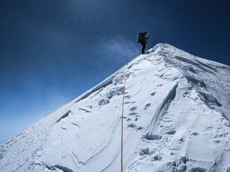
Our second and last full day on the plateau brought moderate winds. But with reasonable visibility, and no signs of imminent doom, we departed our camp in the early morning harbouring high hopes, a camera tripod and two global navigation satellite system receivers. It’s a long and mostly flat trip from the western side of Logan’s plateau to its main summit on the far eastern edge. We didn’t even see the main summit until midday, after carefully side-hilling for hours around Philippe Peak (or West Peak as it’s sometimes called), the second-highest summit on the massif. I kept the receiver batteries in the chest pocket of my inner jacket to keep them warm — the temperature never rose above -25 C. But the winds remained moderate, and so, at the base of the main summit, we quickly took stock, abandoned our skis in favour of crampons and walked together up the final narrow snow ridge to the highest point in Canada.
Our time on Mount Logan’s summit was short — no more than 35 minutes. It was just enough time to let the global navigation satellite system receivers collect the data to get an accurate height measurement, repeat some historical photographs, and slap a few high-fives. I lingered on the top longer than the others, trying in vain to shoot a clear 360-degree panorama, as the famous Swiss mountaineer André Roch had done when he summited during the mountain’s second ascent in 1950. But alas, mists were rolling in from the south, my camera’s shutter was sticking, and my fingers were cold.
Happy but weary, we returned to our high camp 13 hours after leaving it. Our overall sense of urgency wouldn’t really dissipate, though, until we exited the plateau itself the next day, just as cold winds rose and temperatures plummeted. Skis permitted a rapid descent. We were soon tent-bound with little visibility on the lower mountain, and would have to wait for a week before the plane could pick us up. We counted ourselves lucky.
Change. Adaptation. Resilience. These are now perhaps the dominant leitmotifs of our times, ingrained in public and private consciousness, far and wide, as a result of the immense and immediate challenges brought about by the global pandemic. Climate change brings with it even greater challenges for Canada and the world. And its effects are already visible everywhere, mostly.
Upon our return from the mountain in June 2021, we sent the summit data recorded by the global navigation satellite system units to Natural Resources Canada in Ottawa for analysis. The results put the summit height at 5,957 metres above sea level, a difference of two metres from the 1992 measurement. Is the mountain now two metres shorter? The data shows this isn’t actually the case. In fact, the ellipsoidal height — the elevation above the reference surface used by GPS — is, amazingly, within a mere 20 centimetres of the 1992 measurement, testament to the extraordinary efforts made by the ’92 team. The two-metre difference instead comes primarily from an updated sea-level reference surface and geoid modelling in the area, the current thinking on where the average ocean’s surface would lie, if extended inland underneath the massif. Ultimately, though, the change is trivial, not least because the snow depth on the summit is varying all the time.
In view of potential remaining errors in the latest geoid model, due to the ruggedness of the surrounding topography of Mount Logan, it is estimated that the height of 5,957 metres is accurate to — you guessed it — within two metres.
Repeat photography from up high tells a similar nickel-and-dime tale. For instance, the icy landscape André Roch gazed out upon from the main summit nearly three-quarters of a century ago was, beyond the weather and the seasonal variance (his image was taken in mid-June, ours in mid-May), remarkably close to what we found. Even the feathered riming and crystalline wind lips adorning the summit ridge seemed to match up.
But it’s the very lack of visible change up high on Mount Logan’s cold snowy reaches, the sheer resilience of this icy stronghold amid all the pronounced changes occurring down slope and beyond, that’s worth notice — and quickly, too. It’s the other reason Alison Criscitiello seeks to return in the spring of 2022. Preliminary results from our radar survey show ice depths out on the plateau in excess of 300 metres. That’s old ice, containing a datable climate record stretching back as far as 30,000 years.
It may also be “last ice,” in the same way that the region known as the Last Ice Area, spanning the top of Canada and Greenland, is predicted to retain year-round sea ice much longer than elsewhere. But just as with the Last Ice Area, “much longer” on Mount Logan is increasingly looking like not that long at all. And so the race is on to document — and learn from — 30,000 years of climate history before even Mount Logan begins to give in, the melting ice releasing the Earth’s secrets before we have a chance to learn from this last icy stronghold.