For more than 50 years, the Royal Canadian Geographical Society has contributed to growing geographical understanding of Canada – its people, places, culture, environment and economic challenges – by funding research to broaden Canadians’ knowledge and appreciation of Canada.
As one of the oldest organizations in Canada funding geographical research, our research grants and scholarships have enabled students to pursue their passion for geography, sometimes leading to ground-breaking results. This much-needed support has also helped launch the careers of Canada’s brightest minds in geography.
This year, we awarded six scholars reflecting a range of disciplines and geographical reach. Their work highlights the importance of applying geographical methods and technologies, to better understand our landscapes, environment, and sustainable human interaction.
GRADUATE SCHOLARSHIPS
ERIKA BRUMMELL
Pursuing a Masters of Science in Physical Geography at the University of Ottawa
“Assessing Arctic Iceberg Climatology Offshore Eastern Canada”
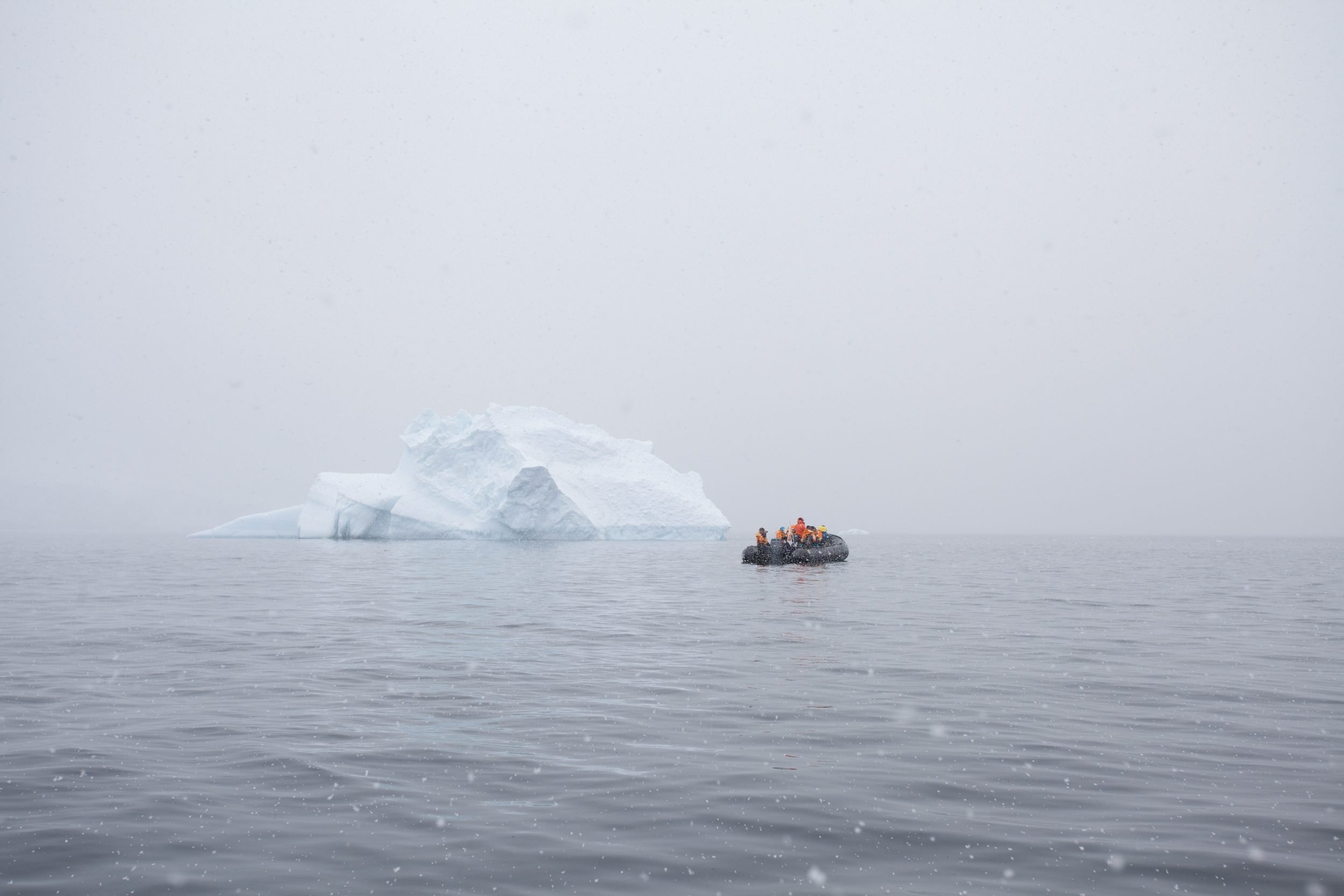
Climate change is strongly impacting Arctic regions, where air temperatures have increased at rates several times faster than the global average, resulting in significant mass loss of glaciers. Canadian tidewater and ice shelves have undergone rapid retreat recently, and iceberg discharge from tidewater glaciers accounts for approximately half of the total mass loss from the Greenland Ice Sheet. Icebergs produced from these regions may present significant risks to vessels operating in iceberg infested waters, especially in shipping corridors, such as in Baffin Bay and Newfoundland and Labrador coast, where annual iceberg counts have surpassed 1,500 per year. However, significant gaps remain in understanding how iceberg distribution is changing over time, and how this impacts the routing and efficiency of shipping in major corridors. In this study, remote sensing data and ice charts from the Canadian Ice Service, International Ice Patrol, and Danish Meteorological Institute are used to evaluate the distribution and southern limit of icebergs offshore Eastern Canada and how it has changed over the last 30 years.
GALEN RICHARDSON
Pursuing a Doctor of Philosophy in Geography at the University of Ottawa
“Tracking the trends, losses, and regrowth of caribou lichen using AI and remote sensing”
Canadian caribou and lichen populations have been declining due to habitat loss and climate change. The objective of this study is to map lichen, the primary food source of caribou, in Quebec, Labrador, and Ontario, using AI and satellite remote sensing. This will allow First Nations community members, policymakers and researchers to better understand changes to lichen in these regions. The objectives of this project will be to develop a suite of tools and maps that can show how lichen coverage has changed over the past 35 years, how lichen coverage is affected by forest fires, and to determine lichen regrowth patterns. This project is being developed in collaboration with the Mushkegowuk Tribal Council, which is providing data and expertise on how to map the loss of lichen. The application and tools will be integrated with other research labs to harmonize approaches to mapping lichen.
JAIME DUBÉ
Pursuing a Master of Science in Physical Geography at the University of Ottawa
“Assessing the supraglacial hydrology of surging glaciers in the St Elias Mountains, Yukon
Nàłùdäy Glacier in the St Elias Mountains has a consistent surge cycle with active phases occurring every 12-20 years. These surges appear to be caused by subglacial water pressure buildup, primarily fed by meltwater from the glacier surface. Field observations indicate that marked changes in surface (supraglacial) hydrology occur during a surge, but little previous work has analyzed these changes in a systematic way and to evaluate whether they are important in driving a surge, or just a product of it. This project therefore aims to evaluate supraglacial hydrology and examine how it evolves throughout a surge cycle. Optical satellite imagery will be used to delineate specific supraglacial features on the glacier. Synthetic aperture radar imagery will be used to map the changes in distribution and extent of crevassing throughout a surge. This project will improve understanding of how meltwater feeds the subglacial hydrological system and promotes surges, and link changing mass balance regimes in the area to mass loss outputs and climate change.
NATHANIEL HOLLOWAY
Pursuing a Masters of Arts in Geography at the University of Ottawa
“Understanding population trends of the aarluk in the eastern Canadian Arctic and associated ecological and social implications”
Climate change-induced alterations to the environment have allowed some species to expand their range to include the Canadian Arctic. One such species which is of particular interest due to its positionality as an upper-trophic level predator is the aarluk (i.e. Orcinus orca; killer whale). The increased presence of aarluk exerts significant pressure on the region’s marine mammal populations which local Inuit rely on for physical health and cultural subsistence, having previously resulted in mostly negative perceptions of the species among Inuit and predictions that the number of conflicts with hunters will increase. Despite its importance, little is known about the species’ future range and distribution and about the associated ecological and social implications of future trends. To fill these knowledge gaps, this two-part study will include a Delphi survey with experts of the aarluk in the Canadian Arctic to develop consensus about the species’ population trends under different climate scenarios to the end of the century, and a focus group and supplementary semi-structured interviews with hunters, fishers, and Elders in the community of Pond Inlet to understand the possible social implications of these trends and map sightings of aarluk in the region.
JAMES BOURQUE NORTHERN DOCTORAL SCHOLARSHIP
SIMONA RUSO
Pursuing a PhD in Geology at Western University
“Characterization of subglacial meltwater features and meltwater drainage dynamics on Devon Island”
Subglacial channels on Devon Island, Nunavut, Canada, are distinct features formed by Innuitian Ice Sheet during the last Ice Age and are morphologically similar to channel-like features on Mars. These channels bear similarity in platform as isolated, finger-like networks that drain into a main stem channel, and in both cross-sectional and longitudinal profiles. Cross-sections are typically flat-bottomed with steep walls and longitudinal profiles are convex and undulous, characteristic of pressurized water flow under ice. For the first time, we use scaling relationships typically applied to rivers to investigate correlations between discharge, size, and drainage area of subglacial channels. In previous work, we found that scalings of channels in Vedra Valles, Mars, are remarkably similar to channels on Devon Island, suggesting they also formed subglacially. Specifically, we suggest these channel networks formed as surface meltwater was routed to the bed via openings in the ice sheet (i.e. moulin or crevasse). This implies temporary, likely episodic, meltwater generation and accommodation at the base of an ice sheet primarily frozen to the ground. These results will be used to enhance the current criteria distinguishing subglacial channels on Earth and can be applied to channels on Mars whose origins are currently unknown.
JAMES MAXWELL HUMAN GEOGRAPHY SCHOLARSHIP
MEAGAN MILLER
Pursuing a MA (Thesis) in Human Geography at the University of Alberta
“Good Homes Take Work: Increasing Accessibility in Edmonton’s Community Housing”
The proposed research is to conduct key-informant interviews with experts in the areas of accessibility and community housing in Edmonton. This will include disabled tenants living in community housing/disability advocates. The aim is to develop understandings of accessibility based on the knowledge and experiences of disabled people in Edmonton’s community housing, and to provide recommendations for enhancing accessibility in this context. From these interviews, the plan is to develop a podcast that reviews accessibility in community housing through digestible 20-30-minute episodes. The central narrative structure will be developed through collaborative means and a thematic analysis of the conducted interviews. The podcast will be used to interview community housing providers in Edmonton where they will be asked to interpret and respond to the podcast material. The podcast will also be released publicly through various online hosting platforms to help disseminate this information to a wider audience, consistent with the emphasis on knowledge mobilization in SSHRC-funded research.
INDEPENDENT RESEARCH GRANT
KIARA CALLADINE
Statistician
“Biodiversity Baseline Expedition to Athabasca Sand Dunes”
This project has been in development for two years and is now focusing on the expedition/field component. To date, we have contacted more than 20 museums across Canada and the United States to obtain information on specimens that have already been collected from the Athabasca Sand Dunes. This exercise indicates that the bulk of specimens resides in three museums (CNC, UASM, and RSKM) and one private collection (J. Acorn) and includes 871 specimens from 205 species. Locality information on these specimens indicate that most of this collecting has been done in the eastern portion of the dune and along the shores of Lake Athabasca near the Thompson Dune field. Our expedition will focus on the western part of the dune complex and along the William River.